

High Grade Gold Anomaly Extended at John Bull in Preparation for Drilling
/EIN News/ -- HIGHLIGHTS
- Detailed mapping, soil sampling and rock chip sampling recently completed by Novo at the John Bull Gold Project follows previously reported outstanding results by TechGen Metals Limited (TechGen) (ASX: TG1)1.
- Novo soil sampling extended the known > 100 ppb Au anomaly to ~ 1.5 km strike with a peak soil result of 1.59 g/t Au.
- Novo rock chip sampling returned peak results of 67.9 g/t Au and 29 g/t Au from sheeted quartz veins in NW and NE trending mineralised structural zones, demonstrating potential for high-grade mineralisation.
- Targets have been defined by high order soil anomalism and including sheeted quartz veins within preferred lithology, fault zones with intense sericite alteration and brecciation; and an Induced Polarisation geophysical anomaly co-incident with a major structure.
- A ~1,500 m RC drill program is planned to commence in June 2025 (drill rig availability dependent), with four key targets identified.
- The recent exploration campaign has significantly enhanced the understanding of the mineral system and strongly supports presence of an Intrusion Related Gold System (IRGS) model.
- Element zonation suggests a proximal Sn-Bi-As core centred on a porphyritic intrusion mapped in the SW of the project area, flanked by intermediate Au-Mo-Cu-Sb-Te zones, and surrounded by the distal halo of sheeted veins with an Au-As-Sb-W association.
- Peak results from multielement sampling include 0.49% W, 780 ppm Sb, 5.6 ppm Mo and 14.9 ppm Bi.
Mike Spreadborough, Executive Co-Chairman and Acting Chief Executive Officer, said: “The recent exploration mapping and sampling campaign at John Bull has provided some exceptional drill targets, which we are excited to test through a ~1,500 m RC program in June.”
“Sourcing drilling contractors is underway and governmental approvals for the drilling campaign are eagerly awaited. Detailed mapping has delineated a large gold system interpreted to be associated with a porphyry in the SW portion of the John Bull tenement. Future work will expand on mapping and sampling to allow targeting of the sheeted-vein system and porphyry-related mineral systems. We look forward to providing an update on the drilling commencement date in the next few weeks.”
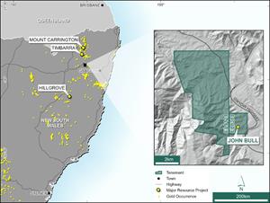
PERTH, West Australia, May 05, 2025 (GLOBE NEWSWIRE) -- Novo Resources Corp. (Novo or the Company) (ASX: NVO) (TSX: NVO) (OTCQB: NSRPF) is pleased to announce results from the exploration campaign at the John Bull Gold Project (John Bull) located in the New England District of NSW (Figure 1), where Novo has a farm-in arrangement with TechGen Metals Limited (ASX: TG1) (TechGen). The program was designed to guide effective targeting for RC drilling scheduled in late June (drill rig availability dependent) and to understand the controls on mineralisation.
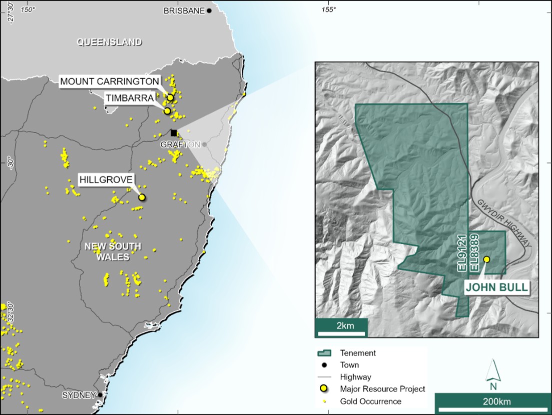
Figure 1: Location of the John Bull Gold Project, in northeastern NSW.
The agreement with TechGen grants Novo an option to acquire an 80% interest in the Mick’s Bull tenement (EL9121) and a 70% interest in the John Bull tenement (EL8389), following two tranches of exploration work and pre-determined expenditure. Refer to Novo’s 13 December 2024 news release titled “Novo strengthens portfolio with two High-Grade gold projects in NSW, Australia” for the detailed terms of the agreement with TechGen.
John Bull is an advanced exploration opportunity, located approximately 49 km WNW of Grafton in the New England district of NSW. The tenure consists of two tenements and covers some 32 sq km (Figure 1). The project lies within the New England Orogen, a region known to host multiple gold and polymetallic mineral systems, including orogenic, intrusion-related, and skarn-style deposits.
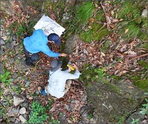
The recent field campaign at John Bull included detailed outcrop mapping (Figure 2), rock chip sampling, and infill and step out soil sampling to be used for characterising local geology, identifying new targets, and investigating current high-value prospects for potential depth or strike extensions and zones of higher-grade mineralisation.
Multiple new targets warrant drill testing. Novo is planning an initial RC drill program of ~ 1,500 m, scheduled to commence in late June (drill rig availability dependent) once all compliance approvals have been received. Drilling will target dense sheeted quartz vein occurrences around the main John Bull historic sluicing area, in addition to three newly developed and untested targets over 1 km of strike highlighted during the recent mapping and surface sampling campaign.

Figure 2 Drone footage of mapping activities at John Bull
Results from Recent Mapping, Soil and Rock Chip Sampling
In February 2025, Novo undertook an intensive campaign comprising geochemical surface sampling and detailed mapping across the John Bull tenement. The primary objective of the field program was to refine the geological understanding and target development ahead of planned drilling, building on previous work completed by TechGen1.
Based on recent mapping, the John Bull prospect represents a structurally controlled Intrusion Related Gold System. Host rocks including greywacke, fine arenite, shale, siltstone, and chert are intruded by several Triassic felsic dykes. Sedimentary rocks are tightly folded into a NW plunging ‘M’-shaped hinge zone which crosses the central part of the prospect (Figure 3). Generally, gold mineralisation is hosted in a very late stage moderately dipping NE-trending sheeted quartz–sulphide vein system, associated with an As–Sb–W geochemical signature. The highest density of sheeted veins and the focus of much of the historic hydraulic sluicing is hosted by an ~80 m thick fine arenite-siltstone unit. This zone is considered the most favourable lithology and is the priority target for drill testing in the upcoming program.
Stratigraphy is offset by regional-scale NW-trending sinistral faults that control the geometry of the Au-As soil anomaly and also represent priority targets. One of these NW trending shears in the central target area has intense sericite alteration and carries grades of up to 29 g/t Au (in recent Novo sampling (see Appendix 1). However, the highest gold grades occur in a NE-trending mineralised breccia mapped over 60 m strike, aligned with historic shafts, which crosscuts stratigraphy and has returned rock chip assays up to 67.9 g/t Au, plus several assay results > 5 g/t Au (Figure 4).
The sheeted vein system is proximal to a porphyry intrusion in the SW part of the John Bull tenement, which has an intense hornfels halo. Geochemical zonation as defined by limited multielement soil geochemistry shows an interpreted proximal Sn–Bi–As enriched core over the porphyry, an intermediate Au–Mo–Cu–Sb–Te zone and a distal Au–As–Sb–W halo (sheeted vein zone), indicating zoned metal dispersion.
Several significant (> 50 ppb) gold results were returned from 315 soil samples; with a peak result of 1.59 g/t Au (see Appendix 2). Infill soil sampling in the north supports the current gold-in-soil anomalism, previously delineated by TechGen – although remains patchy. Refer to Appendix 2 for results.
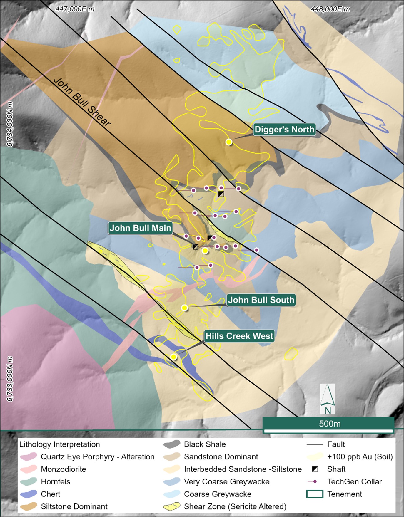
Figure 3 Regional geological interpretation map of the John Bull Project over LiDARTM.
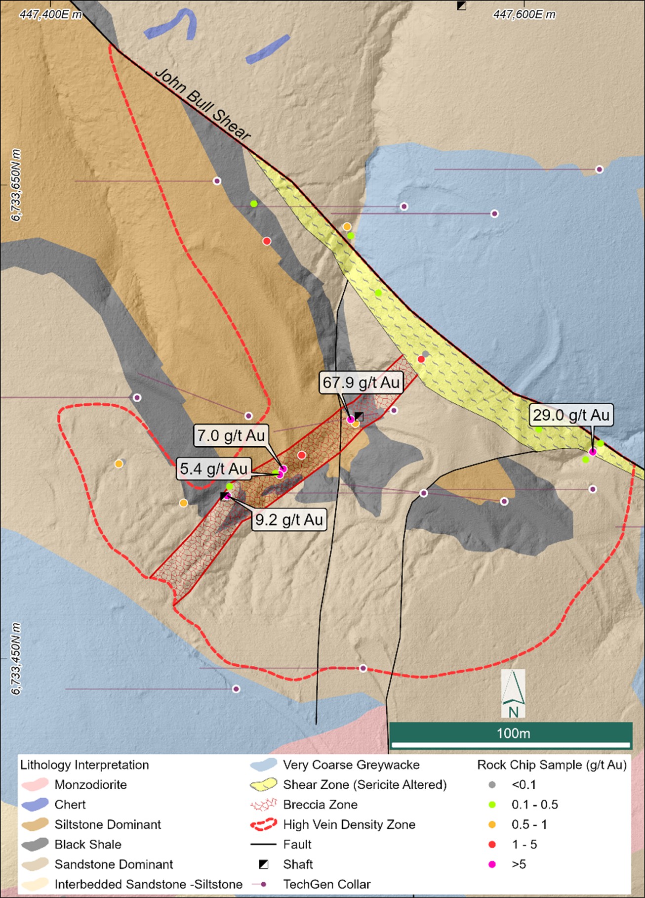
Figure 4 John Bull Main Workings interpreted geology showing preferred stratigraphy and vein arrays where outcrop can be identified. Refer to Appendix 1 for rock chip results
Key Targets and Planned Drill Program
Four target areas have been confirmed for RC drill follow up over 1 km strike length. Drilling will be prioritised in areas with structurally and lithological favourable zones defined by strong Au–As soil anomalies, vein density, and host rock contrasts.
-
John Bull Main – three target areas are planned for testing within this larger zone:
- John Bull Breccia Zone - a NE trending zone approximately 100 m long where recent work yielded high grade rock chip samples including 67.9 g/t Au and three other samples > 5 g/t Au. This linear trend included two historic shafts. Refer to Appendix 1 for all results.
- John Bull Shear – where recent mapping has highlighted strong sericite alteration along a broad NW trending zone of shearing and recent rock chip samples of up to 29 g/t Au. Refer to Appendix 1 for all results.
- John Bull Sluicing Area - where recent mapping has delineated an E-W target zone in a fine sandstone-dominant unit, which was the focus for the main historic sluicing and with the broadest zone of high quartz vein density.
- John Bull South – includes high grade soil anomalies up to 4.77 g/t surrounding and partly overlapping a monzodiorite intrusion, coupled with a large area of historic sluicing for gold. Refer to Appendix 2 for all results.
- Hills Creek West – A coincident IP conductivity anomaly and soil geochemical anomaly with peak value of 2.1 g/t Au1 occur along a regional NW trending fault.
-
Digger’s North – a very broad soil anomaly occurs where limited outcrop is present, in an area north of the previous drilling. Peak soil results include 10.0 g/t Au1 and soil geochemical anomalies are linear along the major NW trending faults within the broader N-S mineralised corridor.
The initial drill program of ~ 1,500 m is planned to commence in late June (drill rig availability dependent) with drilling planned to approximately 140 m depth.
Historic Exploration
Historic mining for gold at John Bull included several shafts and large areas of hydraulic sluicing of elluvial and alluvial gold. Soil sampling completed by TechGen highlighted an exceptionally high-order gold anomaly over 900 m long and 250 m wide at > 100 ppb Au with seven samples reporting > 4.5 g/t Au1.
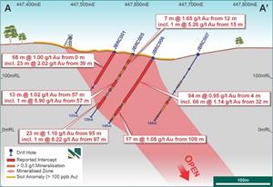
TechGen also completed 17 RC holes for 2,249.5 m (2022 and 2023) with an effective test to ~120 m vertical depth. Peak results from four approximately 100 m spaced E-W sections of shallow RC drilling over 320 m strike (Figure 5) include (Figure 6):
-
94 m @ 0.95 g/t Au from 4 m including 66 m @ 1.14 g/t Au, and
17 m @ 1.08 g/t Au from 109 m (JBRC0006)1 - 68 m @ 1.00 g/t Au from surface including 23 m @ 2.02 g/t Au (JBRC0001)1
Figure 5: John Bull drill hole locations, soil gold geochemical results and historical soil sampling locations. The location of drill Section A-A’ (see below) is also noted.
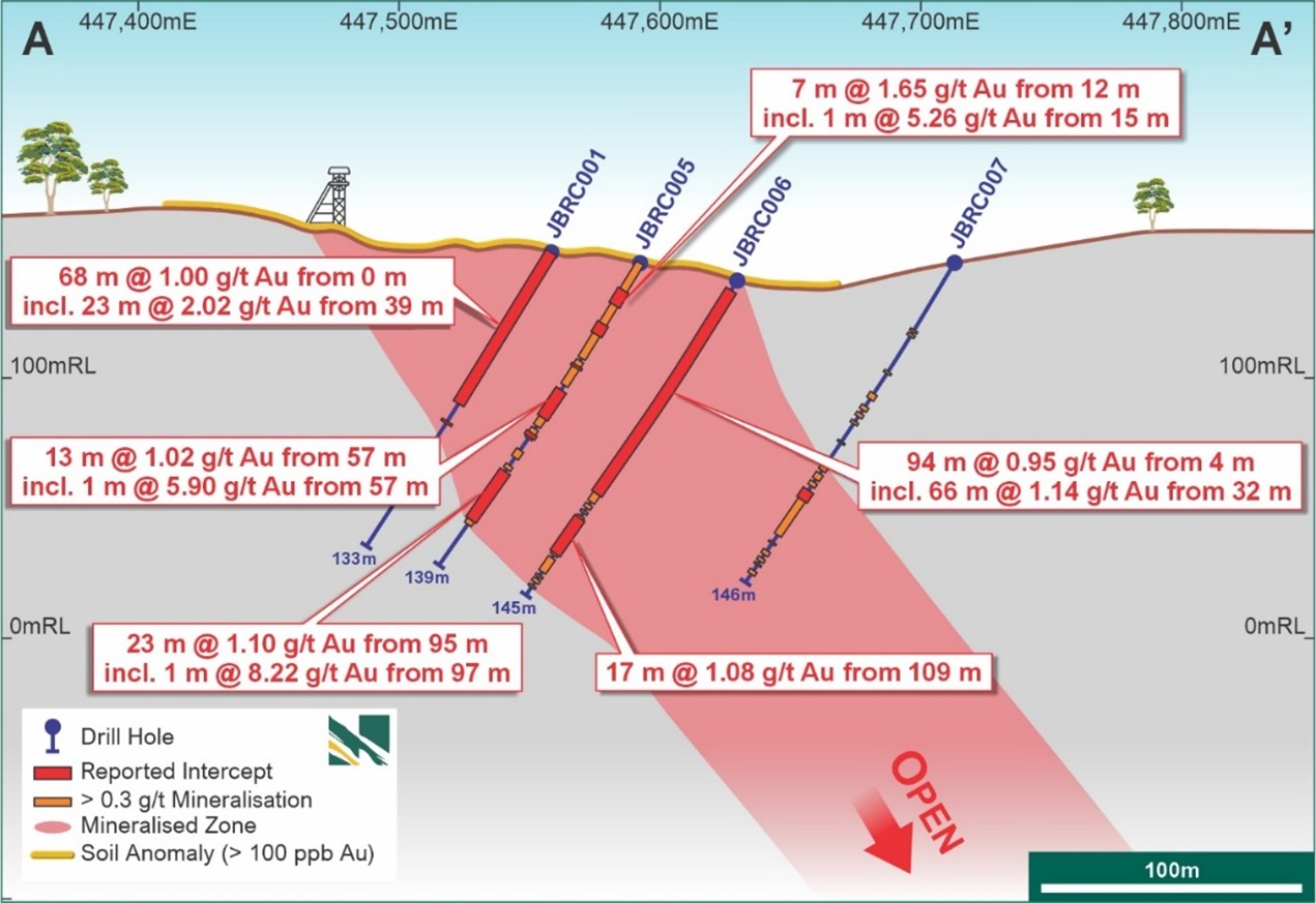
Figure 6 John Bull - E-W Drill section (A-A’ on Figure 5) showing 130 m wide mineralisation and internal higher grades. System open below 120 m depth. Note, wider intercepts have no restriction on internal dilution.
All drill sections remain open at depth and the system remains open along strike. An Induced Polarisation (IP) geophysical survey over part of the target also produced anomalies over known mineralisation.
The above historical results were initially reported by TechGen and have been subsequently reported by Novo in accordance with the JORC Code in its announcment released to ASX on 13 December 2024 – Novo strengthens portfolio with two high-grade gold projects in NSW, Australia
No assurance can be given that Novo will achieve similar results from its upcoming drilling campaign to those disclosed in this section.
Future Work
Exploration activities after the Phase 1 drilling program will include:
- Follow-up drilling pending results from Phase 1 including infill and extensional drill testing and diamond drilling to depth on selected holes.
- Focus on porphyry related targets to the west and SW of the John Bull sheeted vein arrays with possible geophysical surveys and selected drilling.
Further Exploration Update
Exploration work is ongoing in Western Australia and in New South Wales, and below is a summary of the current progress:
- Exploration drilling has been completed at the Balla Balla Gold Project with results pending2; and
- Exploration drilling has commenced at the Tibooburra Gold Project2.
Authorised for release by the Board of Directors.
CONTACT
|
Investors: Mike Spreadborough +61 8 6400 6100 info@novoresources.com |
North American Queries: Leo Karabelas +1 416 543 3120 leo@novoresources.com |
Media: Cameron Gilenko +61 466 984 953 cameron.gilenko@sodali.com |
QP STATEMENT
Mrs. Karen (Kas) De Luca (MAIG), is the qualified person, as defined under National Instrument 43-101 Standards of Disclosure for Mineral Projects, responsible for, and having reviewed and approved, the technical information contained in this news release. Mrs De Luca is Novo’s General Manager Exploration.
JORC COMPLIANCE STATEMENT
New exploration results
The information in this news release that relates to exploration results at the John Bull Project is based on information compiled by Mrs De Luca, who is a full-time employee of Novo Resources Corp. Mrs De Luca is a Competent Person who is a member of the Australian Institute of Geoscientists. Mrs De Luca has sufficient experience that is relevant to the style of mineralisation and the type of deposits under consideration and to the activity being undertaken to qualify as a Competent Person as defined in the 2012 Edition of the 'Australasian Code for Reporting of Exploration Results, Mineral Resources and Ore Reserves'. Mrs De Luca consents to the inclusion in the report of the matters based on her information in the form and context in which it appears.
Previously reported exploration results
The information in this news release that relates to previously reported Exploration Results from Novo’s NSW Gold Portfolio is extracted from Novo's ASX announcement entitled Novo Strengthens Portfolio with Two High-Grade Gold Projects in NSW, Australia released to ASX on 13 December 2024 which is available to view at www.asx.com.au. The Company confirms that it is not aware of any new information or data that materially affects the information included in the original market announcement and that all material assumptions and technical parameters underpinning the estimates in the relevant market announcement continue to apply and have not materially changed. The Company confirms that the form and context in which the competent persons findings are presented have not been materially modified from the original market announcement.
Previously reported exploration target - Belltopper
The information in this news release that relates to the previously reported exploration target at Belltopper is extracted from Novo’s ASX announcement entitled Belltopper Mineralisation Modelling Defines Prospectivity released to ASX on 25 September 2024 which is available to view at www.asx.com.au. The Company confirms that it is not aware of any new information or data that materially affects the information in the original market announcement and that the form and context in which the Competent Person’s findings are presented has not been materially modified from the original market announcement.
FORWARD-LOOKING STATEMENTS
Some statements in this news release may contain “forward-looking statements” within the meaning of Canadian and Australian securities law and regulations. In this news release, such statements include but are not limited to planned exploration activities and the timing of such. These statements address future events and conditions and, as such, involve known and unknown risks, uncertainties and other factors which may cause the actual results, performance or achievements to be materially different from any future results, performance or achievements expressed or implied by the statements. Such factors include, without limitation, customary risks of the resource industry and the risk factors identified in Novo’s annual information form for the year ended December 31, 2024 (which is available under Novo’s profile on SEDAR+ at www.sedarplus.ca and at www.asx.com.au) and in the Company’s prospectus dated 2 August 2023 which is available at www.asx.com.au. Forward-looking statements speak only as of the date those statements are made. Except as required by applicable law, Novo assumes no obligation to update or to publicly announce the results of any change to any forward-looking statement contained or incorporated by reference herein to reflect actual results, future events or developments, changes in assumptions or changes in other factors affecting the forward-looking statements. If Novo updates any forward-looking statement(s), no inference should be drawn that the Company will make additional updates with respect to those or other forward-looking statements.
_______________________________
1 Refer to Novo’s ASX announcement released to ASX on 13 December 2024 – Novo strengthens portfolio with two high-grade gold projects in NSW, Australia.
2 Refer to Novo’s ASX announcement released to ASX on 17 April 2025 – Business Review First Quarter 2025.
ABOUT NOVO
Novo is an Australian based gold explorer listed on the ASX and the TSX focussed on discovering standalone gold projects with > 1 Moz development potential. Novo is an innovative gold explorer with a significant land package covering approximately 5,500 square kilometres in the Pilbara region of Western Australia, along with the 22 square kilometre Belltopper project in the Bendigo Tectonic Zone of Victoria, Australia.
Novo’s key project area in the Pilbara is the Egina Gold Camp, where De Grey Mining (ASX: DEG) is farming-in to form a JV at the Becher Project and surrounding tenements through exploration expenditure of A$25 million within 4 years for a 50% interest. The Becher Project has similar geological characteristics as De Grey’s 12.7 Moz Hemi Project#. Novo is also advancing gold exploration south of Becher in the Egina Gold Camp, part of the Croydon JV (Novo 70%: Creasy Group 30%). Novo continues to undertake early-stage exploration elsewhere across its Pilbara tenement portfolio.
Novo has also formed a lithium joint venture with SQM in the Pilbara which provides shareholder exposure to battery metals.
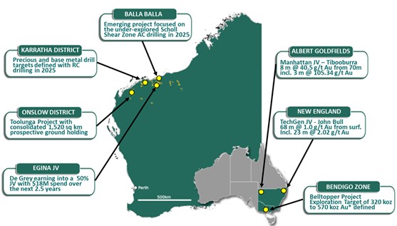
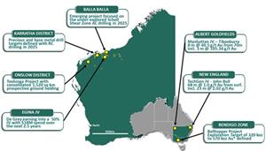
Novo has recently strengthened its high-quality, Australian based exploration portfolio by adding the TechGen John Bull Gold Project in the New England Orogen of NSW, and Manhattan Tibooburra Gold Project in the Albert Goldfields in northwestern NSW. Both projects demonstrate prospectivity for significant discovery and resource definition and align with Novo’s strategy of identifying and exploring projects with > 1 Moz Au potential. These high-grade gold projects compliment the landholding consolidation that forms the Toolunga Project in the Onslow District in Western Australia.
Novo has a significant investment portfolio and a disciplined program in place to identify value accretive opportunities that will build further value for shareholders.
Please refer to Novo’s website for further information including the latest corporate presentation.
*An Exploration Target as defined in the JORC Code (2012) is a statement or estimate of the exploration potential of a mineral deposit in a defined geological setting where the statement or estimate, quoted as a range of tonnes and a range of grade (or quality), relates to mineralisation for which there has been insufficient exploration to estimate a Mineral Resource. Accordingly, these figures are not Mineral Resource or Ore Reserve estimates as defined in the JORC Code (2012). The potential quantities and grades referred to above are conceptual in nature and there has been insufficient exploration to estimate a Mineral Resource and it is uncertain if further exploration will result in the estimation of a Mineral Resource. These figures are based on the interpreted continuity of mineralisation and projection into unexplored ground often around historical workings. The Exploration Target has been prepared in accordance with the JORC Code (2012), as detailed in the Company’s ASX announcement released on 25 September 2024 (available to view at www.asx.com.au). The Tonnage range for the exploration target is 1.5Mt to 2.1Mt, the Grade range is 6.6g/t Au to 8.4g/t Au and the Ounces range from 320koz Au to 570 koz Au. The Company confirms that it is not aware of any new information that materially affects the information included in the original market announcement and that all material assumptions and technical parameters underpinning the estimates in the original market announcement continue to apply and have not materially changed. Dr Christopher Doyle (MAIG) and Dr Simon Dominy (FAusIMM CPGeo; FAIG RPGeo), are the qualified persons, as defined under National Instrument 43-101 Standards of Disclosure for Mineral Projects, responsible for, and having reviewed and approved, the technical information relating to the Exploration Target. Dr Doyle is Novo’s Exploration Manager - Victoria and Dr Dominy is a Technical Advisor to Novo.
#Refer to De Grey’s ASX Announcement, Hemi Gold Project mineral Resource Estimate (MRE) 2024, dated 14 November 2024. No assurance can be given that a similar (or any) commercially viable mineral deposit will be determined at Novo’s Pilbara Projects.
| Appendix 1 –Table of Rock Sample Results, GDA2020 / MGA zone 56 | ||||||||||||||
| SAMPLE_ID | SAMPLE_TYPE | PROGRAM_ID | EASTING | NORTHING | HEIGHT | Au ppm | As ppm | Bi ppm | Cu ppm | Mo ppm | Sb ppm | Sn ppm | Te ppm | W ppm |
| R08001^1 | ROCK | 2025 | 447026 | 6733057 | 211 | 0.32 | >10000 | 8.78 | 5 | 2.37 | 33.7 | 8.3 | 6.77 | 1.5 |
| R08002 | ROCK | 2025 | 446833 | 6733501 | 175 | 0.01 | 287 | 0.35 | 67 | 1.33 | 2.47 | 2.7 | 0.22 | 2.5 |
| R08003 | ROCK | 2025 | 447917 | 6733722 | 123 | 0.01 | 12 | 0.01 | 13 | 1.86 | 2.85 | 0.2 | <0.05 | 0.5 |
| R08005 | ROCK | 2025 | 446758 | 6733398 | 185 | 0.28 | 29 | 2.83 | 233 | 0.53 | 1.55 | 6.8 | 0.32 | 4.1 |
| R08006 | ROCK | 2025 | 447187 | 6733407 | 147 | 0.03 | 39 | 0.32 | 71 | 0.57 | 1.92 | 1.6 | 0.08 | 3.1 |
| R08007 | ROCK | 2025 | 447212 | 6733399 | 150 | <0.01 | 40 | 0.10 | 24 | 0.59 | 2.2 | 1.4 | <0.05 | 3.2 |
| R08008 | ROCK | 2025 | 447216 | 6733388 | 154 | 0.02 | 26 | 0.19 | 42 | 0.45 | 1.22 | 1.9 | <0.05 | 2.6 |
| R08009^1 | ROCK | 2025 | 447262 | 6733373 | 162 | <0.01 | 30 | 0.14 | 16 | 3.1 | 2.95 | 1.7 | <0.05 | 1.9 |
| R08010 | ROCK | 2025 | 447382 | 6733394 | 193 | <0.01 | 40 | 0.06 | 35 | 0.4 | 1.96 | 1.2 | <0.05 | 2.1 |
| R08011^1 | ROCK | 2025 | 446923 | 6733206 | 204 | <0.01 | 38 | 0.21 | 35 | 0.58 | 0.95 | 4.4 | <0.05 | 2 |
| R08012 | ROCK | 2025 | 448069 | 6734186 | 112 | 0.65 | 2010 | 0.05 | 19 | 1.24 | 5.59 | 0.2 | <0.05 | 0.9 |
| R08013 | ROCK | 2025 | 447560 | 6733956 | 149 | 0.13 | 1535 | 0.07 | 11 | 0.94 | 3.68 | 0.3 | 0.27 | 1.3 |
| R08014 | ROCK | 2025 | 446971 | 6733687 | 137 | 0.02 | 78 | 0.24 | 17 | 1.54 | 1.95 | 1.4 | 0.05 | 2.5 |
| R08015 | ROCK | 2025 | 446951 | 6733679 | 139 | <0.01 | 107 | 0.12 | 56 | 5.57 | 1.71 | 1.9 | <0.05 | 4.8 |
| R08017 | ROCK | 2025 | 446846 | 6733674 | 147 | <0.01 | 5110 | 0.36 | 8 | 0.71 | 5.97 | 2 | 0.29 | 11.3 |
| R08018 | ROCK | 2025 | 446801 | 6733687 | 150 | 0.02 | 59 | 0.15 | 25 | 2.22 | 2.03 | 1.9 | 0.05 | 8.9 |
| R08022^1 | ROCK | 2025 | 446860 | 6733281 | 228 | 0.75 | >10000 | 0.70 | 101 | 3.23 | 780 | 15.9 | 1.03 | 1 |
| R08023^1 | ROCK | 2025 | 446859 | 6733282 | 228 | 0.06 | 222 | 0.94 | 94 | 0.61 | 4.54 | 4.9 | 0.14 | 5.3 |
| R08024 | ROCK | 2025 | 447406 | 6733350 | 189 | 0.03 | 96 | 0.19 | 14 | 2.65 | 2.46 | 1 | <0.05 | 1.7 |
| R08025^1 | ROCK | 2025 | 447761 | 6733657 | 123 | 0.12 | 4310 | 0.07 | 12 | 0.51 | 10.3 | 0.8 | 0.30 | 4.7 |
| R08026^1 | ROCK | 2025 | 447771 | 6733648 | 125 | <0.01 | 950 | 0.20 | 436 | 0.28 | 61.8 | 0.4 | 0.13 | 2.8 |
| R08028 | ROCK | 2025 | 446774 | 6733151 | 200 | 0.01 | 56 | 0.35 | 44 | 0.81 | 1.28 | 0.5 | 0.10 | 1 |
| R08029 | ROCK | 2025 | 446739 | 6733100 | 200 | 0.01 | 101 | 0.49 | 31 | 1.18 | 2.09 | 4.9 | 0.15 | 1.9 |
| R08030 | ROCK | 2025 | 446855 | 6732907 | 200 | 0.01 | 1890 | 14.85 | 16 | 0.82 | 3.4 | 22.1 | <0.05 | 144.5 |
| R08034 | ROCK | 2025 | 447529 | 6733551 | 139 | 0.78 | 5060 | 0.17 | 35 | 0.87 | 6.54 | 1.5 | 0.07 | 3.5 |
| R08035 | ROCK | 2025 | 447527 | 6733555 | 139 | 0.02 | 345 | 0.26 | 39 | 0.56 | 3.27 | 2.5 | <0.05 | 3.2 |
| R08036 | ROCK | 2025 | 447527 | 6733552 | 139 | 67.9 | 1240 | 1.11 | 9 | 0.76 | 3.92 | 0.6 | <0.05 | 1.5 |
| R08037 | ROCK | 2025 | 447507 | 6733537 | 144 | 1.12 | 2520 | 0.14 | 10 | 0.85 | 8.11 | 0.7 | 0.06 | 6 |
| R08038 | ROCK | 2025 | 447499 | 6733532 | 147 | 7.0 | 5730 | 0.41 | 4 | 0.57 | 11.2 | 0.8 | 0.05 | 2.2 |
| R08039 | ROCK | 2025 | 447497 | 6733529 | 147 | 5.43 | >10000 | 0.62 | 8 | 0.8 | 13.25 | 0.5 | 0.12 | 2.2 |
| R08040 | ROCK | 2025 | 447496 | 6733530 | 148 | 0.43 | 8990 | 0.19 | 18 | 0.77 | 7.68 | 1.1 | 0.05 | 4 |
| R08042 | ROCK | 2025 | 447492 | 6733628 | 138 | 1.2 | 1975 | 0.37 | 25 | 0.7 | 4.53 | 1.9 | 0.07 | 11.1 |
| R08043 | ROCK | 2025 | 447487 | 6733644 | 136 | 0.49 | 3230 | 0.37 | 27 | 1.1 | 5.98 | 1.6 | 0.10 | 12 |
| R08044 | ROCK | 2025 | 447675 | 6733572 | 128 | 0.01 | 159 | 0.07 | 27 | 0.42 | 1.68 | 1.3 | <0.05 | 4.9 |
| R08045 | ROCK | 2025 | 447540 | 6733556 | 140 | 0.03 | 586 | 0.20 | 16 | 1.06 | 2.89 | 3 | <0.05 | 5.3 |
| R08046 | ROCK | 2025 | 447607 | 6733548 | 138 | 0.15 | 518 | 0.14 | 29 | 0.54 | 1.56 | 1.3 | 0.06 | 6.5 |
| R08047 | ROCK | 2025 | 447633 | 6733542 | 132 | 0.36 | 2130 | 0.12 | 28 | 0.53 | 3.92 | 1.2 | 0.14 | 354 |
| R08048 | ROCK | 2025 | 447630 | 6733539 | 133 | 29.0 | 5650 | 0.28 | 26 | 0.69 | 7.05 | 1.7 | 0.49 | 4850 |
| R08049 | ROCK | 2025 | 447627 | 6733536 | 134 | 0.21 | 974 | 0.16 | 33 | 0.53 | 2.9 | 1.4 | 0.08 | 27.7 |
| R08050 | ROCK | 2025 | 447557 | 6733578 | 141 | 2.23 | 758 | 0.63 | 38 | 0.83 | 3.01 | 2.3 | 0.10 | 18.3 |
| R08051 | ROCK | 2025 | 447539 | 6733606 | 136 | 0.27 | 4900 | 0.26 | 24 | 0.76 | 6.74 | 2.3 | 0.09 | 8.3 |
| R08052 | ROCK | 2025 | 447527 | 6733630 | 128 | 0.11 | 1395 | 0.38 | 42 | 0.46 | 5.91 | 2.5 | 0.09 | 10.3 |
| R08053 | ROCK | 2025 | 447526 | 6733634 | 127 | 0.56 | 639 | 0.34 | 31 | 0.48 | 2.94 | 1.9 | 0.06 | 11.7 |
| R08054 | ROCK | 2025 | 447559 | 6733580 | 141 | 0.06 | 161 | 0.20 | 35 | 0.68 | 2.11 | 2.1 | <0.05 | 4.2 |
| R08082 | ROCK | 2025 | 447812 | 6734365 | 115 | 0.01 | 60 | 0.11 | 25 | 0.33 | 1.75 | 1.3 | <0.05 | 4.8 |
| R08083^1 | ROCK | 2025 | 447635 | 6734184 | 131 | 0.09 | 29 | 0.20 | 27 | 0.44 | 1.5 | 1 | <0.05 | 3.6 |
| R08084 | ROCK | 2025 | 447671 | 6734210 | 128 | 0.04 | 80 | 0.12 | 33 | 0.51 | 2.4 | 1.3 | <0.05 | 4.5 |
| R08085 | ROCK | 2025 | 447775 | 6734483 | 132 | 0.03 | 174 | 0.05 | 10 | 0.97 | 3.13 | 0.5 | 0.05 | 2.8 |
| R08086 | ROCK | 2025 | 447431 | 6734123 | 132 | 0.01 | 40 | 0.33 | 7 | 1.28 | 0.69 | 2.8 | <0.05 | 1.2 |
| R08088 | ROCK | 2025 | 447428 | 6734114 | 132 | 0.01 | 205 | 0.31 | 32 | 0.45 | 3.45 | 2.5 | 0.05 | 2.8 |
| R08089 | ROCK | 2025 | 447353 | 6734105 | 136 | 0.22 | 390 | 0.19 | 28 | 0.39 | 3.33 | 1.4 | 0.11 | 4.9 |
| R08090 | ROCK | 2025 | 447457 | 6733517 | 160 | 0.55 | 4110 | 0.28 | 9 | 0.79 | 16.45 | 1.3 | 0.11 | 3.2 |
| R08091 | ROCK | 2025 | 447475 | 6733520 | 156 | 9.18 | >10000 | 0.88 | 10 | 0.96 | 30.9 | 0.4 | 0.28 | 22 |
| R08092 | ROCK | 2025 | 447476 | 6733524 | 154 | 0.15 | 1655 | 0.18 | 7 | 1.42 | 4.41 | 3 | <0.05 | 3.9 |
| R08093 | ROCK | 2025 | 447431 | 6733534 | 159 | 0.04 | 267 | 0.06 | 21 | 1.2 | 1.46 | 1.1 | <0.05 | 2.3 |
| R08094 | ROCK | 2025 | 447430 | 6733534 | 159 | 0.86 | 3990 | 0.25 | 10 | 0.81 | 6.26 | 1.3 | 0.08 | 2.3 |
| R08095 | ROCK | 2025 | 447356 | 6733666 | 123 | 2.14 | 3710 | 1.12 | 18 | 0.49 | 5.54 | 1.9 | 0.87 | 3 |
| R08096 | ROCK | 2025 | 447351 | 6733666 | 123 | 0.05 | 37 | 0.23 | 29 | 0.64 | 2.13 | 1.7 | 0.05 | 1.9 |
| R08097 | ROCK | 2025 | 447699 | 6733600 | 124 | 0.11 | 209 | 0.03 | 10 | 0.81 | 1.59 | 0.2 | <0.05 | 0.4 |
| R08098 | ROCK | 2025 | 447698 | 6733603 | 123 | 0.21 | 1750 | 0.12 | 27 | 0.38 | 3.19 | 0.9 | 0.05 | 3.1 |
| R08099 | ROCK | 2025 | 447432 | 6734124 | 132 | 0.01 | 86 | 0.42 | 11 | 1.98 | 1.92 | 2.4 | <0.05 | 0.9 |
^1 = Sample recorded as FLOAT.
| Appendix 2 –Table of Soil Sample Results (20 ppb Au or greater), GDA2020 / MGA zone 56 | |||||||||||||
| SAMPLE_ID | SAMPLE_TYPE | PROGRAM_ID | EASTING | NORTHING | HEIGHT | Au ppm | As ppm | Bi ppm | Cu ppm | Mo ppm | Sb ppm | Sn ppm | W ppm |
| J6001 | SOIL | 2025 | 447,249 | 6,732,998 | 156 | 0.02 | 80 | 0.22 | 15 | 1.34 | 1.5 | 2.09 | 3.24 |
| J6010 | SOIL | 2025 | 447,351 | 6,732,950 | 144 | 0.02 | 31 | 0.14 | 16 | 0.84 | 1.17 | 1.62 | 3.11 |
| J6012 | SOIL | 2025 | 447,352 | 6,732,850 | 128 | 0.02 | 59 | 0.76 | 56 | 1.85 | 1.64 | 3.58 | 3.09 |
| J6014 | SOIL | 2025 | 447,399 | 6,732,950 | 135 | 0.08 | 67 | 0.18 | 15 | 0.94 | 1.98 | 1.48 | 3.73 |
| J6017 | SOIL | 2025 | 447,451 | 6,732,999 | 132 | 0.06 | 76 | 0.17 | 17 | 2.22 | 3.11 | 1.47 | 7.22 |
| J6018 | SOIL | 2025 | 447,450 | 6,732,950 | 129 | 0.02 | 81 | 0.04 | 74 | 0.89 | 2.05 | 1.46 | 3.43 |
| J6019 | SOIL | 2025 | 447,452 | 6,732,894 | 122 | 0.02 | 78 | 0.82 | 60 | 1.98 | 2.48 | 4.61 | 4.76 |
| J6022 | SOIL | 2025 | 447,402 | 6,732,848 | 129 | 0.05 | 140 | 0.25 | 39 | 0.8 | 1.4 | 1.67 | 7.26 |
| J6023 | SOIL | 2025 | 447,500 | 6,732,846 | 125 | 0.02 | 51 | 0.16 | 19 | 0.81 | 1.92 | 1.6 | 3.28 |
| J6024 | SOIL | 2025 | 447,500 | 6,732,901 | 121 | 0.02 | 73 | 0.57 | 62 | 1.7 | 1.9 | 3.52 | 3.56 |
| J6025 | SOIL | 2025 | 447,506 | 6,732,951 | 122 | 0.29 | 79 | 0.19 | 22 | 1.57 | 3.04 | 1.78 | 4.48 |
| J6027 | SOIL | 2025 | 447,651 | 6,732,999 | 115 | 0.02 | 97 | 0.99 | 85 | 2.04 | 2.68 | 4.52 | 4.27 |
| J6028 | SOIL | 2025 | 447,650 | 6,732,949 | 123 | 0.09 | 97 | 0.13 | 18 | 1.03 | 3.29 | 1.31 | 6.69 |
| J6031 | SOIL | 2025 | 447,600 | 6,732,849 | 137 | 0.02 | 76 | 0.17 | 13 | 2.17 | 3.7 | 1.29 | 6.94 |
| J6037 | SOIL | 2025 | 447,799 | 6,734,347 | 120 | 0.04 | 91 | 0.15 | 20 | 1.85 | 2.81 | 1.61 | 6.19 |
| J6038 | SOIL | 2025 | 447,725 | 6,734,350 | 139 | 0.96 | 181 | 0.16 | 28 | 1.02 | 2.97 | 1.69 | 9.56 |
| J6039 | SOIL | 2025 | 447,676 | 6,734,350 | 154 | 0.24 | 89 | 0.16 | 29 | 0.64 | 2.51 | 1.73 | 11.20 |
| J6040 | SOIL | 2025 | 447,625 | 6,734,350 | 164 | 0.29 | 79 | 0.16 | 26 | 0.57 | 2.72 | 1.52 | 7.51 |
| J6041 | SOIL | 2025 | 447,576 | 6,734,349 | 170 | 0.04 | 103 | 0.17 | 30 | 0.74 | 2.44 | 1.75 | 5.59 |
| J6042 | SOIL | 2025 | 447,527 | 6,734,349 | 172 | 0.09 | 173 | 0.17 | 26 | 0.83 | 2.57 | 1.85 | 6.59 |
| J6048 | SOIL | 2025 | 447,250 | 6,734,350 | 187 | 0.05 | 38 | 0.13 | 18 | 0.81 | 2.31 | 1.47 | 3.84 |
| J6050 | SOIL | 2025 | 447,727 | 6,734,376 | 139 | 0.06 | 146 | 0.15 | 28 | 0.73 | 2.82 | 1.64 | 6.36 |
| J6051 | SOIL | 2025 | 447,700 | 6,733,000 | 119 | 0.04 | 136 | 0.13 | 19 | 0.83 | 3.76 | 1.47 | 11.75 |
| J6052 | SOIL | 2025 | 447,701 | 6,732,949 | 130 | 0.02 | 191 | 0.12 | 15 | 1.06 | 4.53 | 1.31 | 6.40 |
| J6053 | SOIL | 2025 | 447,701 | 6,732,899 | 137 | 0.03 | 111 | 0.14 | 19 | 1.18 | 4.1 | 1.19 | 3.97 |
| J6057 | SOIL | 2025 | 447,750 | 6,732,950 | 131 | 0.02 | 181 | 0.15 | 19 | 0.86 | 3.8 | 1.35 | 6.75 |
| J6058 | SOIL | 2025 | 447,751 | 6,733,001 | 125 | 0.02 | 137 | 0.12 | 18 | 0.9 | 3.72 | 1.56 | 6.30 |
| J6059 | SOIL | 2025 | 447,600 | 6,733,000 | 116 | 0.02 | 75 | 0.15 | 17 | 1.22 | 2.18 | 1.4 | 7.06 |
| J6061 | SOIL | 2025 | 447,550 | 6,732,949 | 121 | 0.03 | 157 | 0.57 | 137 | 7.26 | 18.35 | 2.75 | 5.92 |
| J6062 | SOIL | 2025 | 447,799 | 6,734,399 | 125 | 0.02 | 202 | 0.20 | 34 | 0.96 | 3 | 1.66 | 6.99 |
| J6064 | SOIL | 2025 | 447,700 | 6,734,400 | 149 | 0.02 | 192 | 0.20 | 25 | 0.89 | 3.48 | 1.6 | 7.08 |
| J6066 | SOIL | 2025 | 447,650 | 6,734,400 | 161 | 0.05 | 212 | 0.21 | 25 | 0.8 | 3.17 | 1.72 | 8.20 |
| J6067 | SOIL | 2025 | 447,601 | 6,734,400 | 168 | 0.03 | 156 | 0.21 | 29 | 0.59 | 2.83 | 1.64 | 8.97 |
| J6068 | SOIL | 2025 | 447,550 | 6,734,399 | 170 | 0.09 | 132 | 0.19 | 28 | 0.83 | 2.6 | 1.76 | 8.77 |
| J6074 | SOIL | 2025 | 447,300 | 6,734,399 | 167 | 0.03 | 102 | 0.13 | 30 | 0.9 | 2.62 | 1.55 | 3.08 |
| J6076 | SOIL | 2025 | 447,701 | 6,734,376 | 148 | 0.52 | 119 | 0.17 | 27 | 0.86 | 2.66 | 1.6 | 6.02 |
| J6077 | SOIL | 2025 | 447,676 | 6,734,375 | 155 | 0.04 | 151 | 0.18 | 23 | 0.74 | 2.89 | 1.58 | 7.31 |
| J6078 | SOIL | 2025 | 447,650 | 6,734,375 | 161 | 0.07 | 164 | 0.18 | 22 | 1.06 | 2.55 | 1.66 | 7.13 |
| J6080 | SOIL | 2025 | 447,601 | 6,734,375 | 170 | 0.03 | 120 | 0.23 | 33 | 0.84 | 3.02 | 1.72 | 7.94 |
| J6081 | SOIL | 2025 | 447,576 | 6,734,376 | 173 | 0.04 | 145 | 0.21 | 28 | 0.73 | 3.01 | 1.72 | 10.95 |
| J6082 | SOIL | 2025 | 447,551 | 6,734,374 | 174 | 0.52 | 229 | 0.20 | 30 | 0.98 | 3.07 | 1.68 | 10.20 |
| J6083 | SOIL | 2025 | 447,301 | 6,734,376 | 175 | 0.03 | 101 | 0.16 | 29 | 0.81 | 3.11 | 1.58 | 3.60 |
| J6088 | SOIL | 2025 | 447,400 | 6,734,375 | 170 | 0.34 | 36 | 0.23 | 26 | 0.88 | 3.2 | 2.06 | 2.64 |
| J6090 | SOIL | 2025 | 447,450 | 6,734,375 | 171 | 0.04 | 158 | 0.17 | 19 | 0.78 | 2.3 | 1.54 | 4.82 |
| J6092 | SOIL | 2025 | 447,500 | 6,734,374 | 172 | 0.02 | 58 | 0.18 | 30 | 0.62 | 2.7 | 1.8 | 4.38 |
| J6093 | SOIL | 2025 | 447,526 | 6,734,374 | 174 | 0.13 | 195 | 0.20 | 27 | 0.95 | 2.88 | 1.69 | 7.13 |
| J6098 | SOIL | 2025 | 447,301 | 6,734,449 | 148 | 0.02 | 91 | 0.17 | 29 | 0.88 | 2.68 | 1.68 | 3.29 |
| J6100 | SOIL | 2025 | 447,749 | 6,734,500 | 136 | 0.03 | 309 | 0.24 | 21 | 0.92 | 3.84 | 1.44 | 7.66 |
| J6101 | SOIL | 2025 | 447,750 | 6,734,549 | 129 | 0.2 | 189 | 0.20 | 25 | 0.81 | 3.17 | 1.53 | 5.58 |
| J6103 | SOIL | 2025 | 447,800 | 6,734,598 | 118 | 0.05 | 283 | 0.19 | 21 | 0.95 | 2.93 | 1.6 | 7.13 |
| J6104 | SOIL | 2025 | 447,800 | 6,734,549 | 125 | 0.02 | 153 | 0.24 | 27 | 0.77 | 3.91 | 1.44 | 4.13 |
| J6105 | SOIL | 2025 | 447,800 | 6,734,499 | 127 | 0.02 | 288 | 0.17 | 30 | 1.17 | 3.95 | 1.44 | 5.97 |
| J6107 | SOIL | 2025 | 447,750 | 6,734,450 | 139 | 0.13 | 298 | 0.21 | 25 | 1.03 | 3.73 | 1.53 | 6.69 |
| J6109 | SOIL | 2025 | 447,301 | 6,734,500 | 132 | 0.09 | 94 | 0.20 | 23 | 1.25 | 2.58 | 1.6 | 3.35 |
| J6110 | SOIL | 2025 | 447,348 | 6,734,498 | 134 | 0.03 | 43 | 0.19 | 20 | 0.92 | 2.56 | 1.52 | 3.10 |
| J6113 | SOIL | 2025 | 447,325 | 6,734,327 | 183 | 0.07 | 65 | 0.19 | 26 | 1.23 | 2.86 | 1.75 | 3.33 |
| J6122 | SOIL | 2025 | 447,500 | 6,734,325 | 165 | 0.34 | 104 | 0.16 | 24 | 0.92 | 2.43 | 1.74 | 4.79 |
| J6123 | SOIL | 2025 | 447,526 | 6,734,325 | 165 | 0.11 | 216 | 0.16 | 27 | 0.79 | 2.27 | 1.64 | 5.22 |
| J6124 | SOIL | 2025 | 447,551 | 6,734,325 | 165 | 0.02 | 113 | 0.17 | 29 | 1.02 | 2.55 | 1.73 | 7.26 |
| J6125 | SOIL | 2025 | 447,575 | 6,734,324 | 164 | 0.03 | 76 | 0.19 | 23 | 0.71 | 2.81 | 1.72 | 6.05 |
| J6126 | SOIL | 2025 | 447,601 | 6,734,325 | 162 | 0.1 | 116 | 0.17 | 26 | 0.92 | 2.78 | 1.51 | 11.40 |
| J6127 | SOIL | 2025 | 447,623 | 6,734,324 | 160 | 0.04 | 90 | 0.16 | 24 | 0.62 | 2.37 | 1.63 | 7.54 |
| J6128 | SOIL | 2025 | 447,650 | 6,734,323 | 157 | 0.37 | 67 | 0.14 | 24 | 0.74 | 2.05 | 1.59 | 9.38 |
| J6129 | SOIL | 2025 | 447,676 | 6,734,326 | 153 | 0.04 | 107 | 0.12 | 24 | 0.6 | 2.2 | 1.44 | 9.09 |
| J6130 | SOIL | 2025 | 447,699 | 6,734,326 | 148 | 0.03 | 95 | 0.14 | 25 | 1.23 | 2.51 | 1.62 | 9.83 |
| J6131 | SOIL | 2025 | 447,727 | 6,734,324 | 140 | 0.03 | 122 | 0.15 | 26 | 0.88 | 2.55 | 1.68 | 10.05 |
| J6132 | SOIL | 2025 | 447,753 | 6,734,326 | 134 | 0.04 | 145 | 0.15 | 27 | 1.35 | 2.85 | 1.51 | 6.95 |
| J6133 | SOIL | 2025 | 447,624 | 6,734,297 | 153 | 0.04 | 118 | 0.17 | 26 | 0.77 | 2.34 | 1.67 | 11.85 |
| J6134 | SOIL | 2025 | 447,676 | 6,734,302 | 149 | 0.33 | 252 | 0.18 | 29 | 0.99 | 3.12 | 1.71 | 20.50 |
| J6136 | SOIL | 2025 | 447,727 | 6,734,300 | 136 | 0.02 | 213 | 0.13 | 19 | 0.8 | 2.65 | 1.62 | 9.49 |
| J6137 | SOIL | 2025 | 447,800 | 6,734,302 | 120 | 0.25 | 182 | 0.13 | 23 | 1.34 | 2.56 | 1.38 | 6.99 |
| J6138 | SOIL | 2025 | 447,451 | 6,734,500 | 137 | 0.03 | 45 | 0.16 | 25 | 1.14 | 2.38 | 1.66 | 3.73 |
| J6146 | SOIL | 2025 | 447,300 | 6,734,598 | 151 | 0.05 | 36 | 0.17 | 20 | 0.99 | 2.62 | 1.51 | 2.69 |
| J6150 | SOIL | 2025 | 447,249 | 6,734,300 | 200 | 0.04 | 23 | 0.11 | 18 | 0.97 | 2.41 | 1.39 | 3.29 |
| J6155 | SOIL | 2025 | 447,524 | 6,734,299 | 157 | 0.02 | 150 | 0.18 | 23 | 1.22 | 2.65 | 1.83 | 5.44 |
| J6156 | SOIL | 2025 | 447,575 | 6,734,298 | 155 | 0.02 | 101 | 0.18 | 25 | 0.7 | 2.5 | 3.98 | 7.89 |
| J6158 | SOIL | 2025 | 447,325 | 6,734,277 | 179 | 0.23 | 28 | 0.10 | 19 | 1.23 | 2.12 | 1.35 | 4.68 |
| J6162 | SOIL | 2025 | 447,425 | 6,734,274 | 156 | 0.05 | 38 | 0.12 | 30 | 1.54 | 2.16 | 1.4 | 4.11 |
| J6173 | SOIL | 2025 | 447,101 | 6,732,899 | 212 | 0.02 | 86 | 0.73 | 19 | 1.94 | 2.78 | 3.62 | 2.58 |
| J6174 | SOIL | 2025 | 447,152 | 6,732,899 | 196 | 0.05 | 63 | 0.59 | 12 | 1.16 | 1.97 | 3.11 | 2.97 |
| J6178 | SOIL | 2025 | 447,151 | 6,732,849 | 199 | 0.03 | 43 | 0.51 | 13 | 1.46 | 1.96 | 2.74 | 2.43 |
| J6180 | SOIL | 2025 | 447,101 | 6,733,001 | 179 | 0.02 | 181 | 1.57 | 48 | 1.96 | 3.22 | 3.57 | 2.28 |
| J6182 | SOIL | 2025 | 447,201 | 6,733,001 | 158 | 0.02 | 79 | 0.71 | 12 | 1.46 | 1.68 | 2.72 | 2.91 |
| J6186 | SOIL | 2025 | 446,751 | 6,733,098 | 298 | 0.02 | 79 | 0.89 | 20 | 1.26 | 2.17 | 3.14 | 2.12 |
| J6187 | SOIL | 2025 | 446,751 | 6,733,150 | 280 | 0.21 | 268 | 2.88 | 80 | 5.38 | 3.9 | 6.25 | 3.28 |
| J6188 | SOIL | 2025 | 446,749 | 6,733,200 | 259 | 0.04 | 176 | 1.06 | 72 | 6.37 | 9.57 | 3.19 | 2.16 |
| J6190 | SOIL | 2025 | 446,750 | 6,733,301 | 217 | 0.07 | 181 | 0.60 | 27 | 1.94 | 4.31 | 2.87 | 2.09 |
| J6193 | SOIL | 2025 | 446,751 | 6,733,448 | 178 | 0.03 | 57 | 0.27 | 27 | 1.2 | 1.02 | 1.5 | 2.82 |
| J6194 | SOIL | 2025 | 446,755 | 6,733,502 | 166 | 0.02 | 253 | 0.84 | 67 | 3.09 | 5.43 | 3.35 | 3.00 |
| J6196 | SOIL | 2025 | 446,750 | 6,733,546 | 168 | 0.04 | 138 | 0.13 | 21 | 1.42 | 3.16 | 1.34 | 3.46 |
| J6208 | SOIL | 2025 | 446,950 | 6,732,999 | 252 | 0.03 | 244 | 1.45 | 50 | 2.48 | 3.89 | 11.7 | 2.18 |
| J6211 | SOIL | 2025 | 446,852 | 6,733,050 | 259 | 0.03 | 150 | 0.99 | 100 | 6.66 | 6.98 | 5.41 | 2.65 |
| J6214 | SOIL | 2025 | 446,849 | 6,733,197 | 241 | 0.02 | 115 | 0.53 | 26 | 2.3 | 3.2 | 2.96 | 2.27 |
| J6216 | SOIL | 2025 | 446,851 | 6,733,249 | 236 | 0.02 | 56 | 0.22 | 18 | 1.71 | 2.26 | 3.53 | 2.85 |
| J6223 | SOIL | 2025 | 446,849 | 6,733,549 | 168 | 0.03 | 59 | 0.44 | 12 | 0.92 | 1.03 | 1.52 | 3.15 |
| J6227 | SOIL | 2025 | 447,799 | 6,734,198 | 107 | 0.03 | 149 | 0.11 | 19 | 0.87 | 2.45 | 1.33 | 9.47 |
| J6228 | SOIL | 2025 | 447,799 | 6,734,248 | 113 | 0.04 | 185 | 0.11 | 19 | 0.9 | 2.91 | 1.45 | 11.50 |
| J6229 | SOIL | 2025 | 447,499 | 6,734,275 | 151 | 0.05 | 96 | 0.20 | 25 | 0.83 | 2.55 | 1.9 | 5.51 |
| J6230 | SOIL | 2025 | 447,527 | 6,734,273 | 150 | 1.59 | 156 | 0.18 | 26 | 0.81 | 2.53 | 1.81 | 6.54 |
| J6231 | SOIL | 2025 | 447,549 | 6,734,274 | 148 | 0.04 | 116 | 0.17 | 26 | 0.7 | 2.29 | 1.65 | 6.85 |
| J6233 | SOIL | 2025 | 447,602 | 6,734,273 | 149 | 0.07 | 142 | 0.18 | 28 | 0.8 | 3.12 | 1.79 | 11.90 |
| J6234 | SOIL | 2025 | 447,625 | 6,734,275 | 148 | 0.04 | 140 | 0.19 | 28 | 0.75 | 2.8 | 1.92 | 9.71 |
| J6236 | SOIL | 2025 | 447,651 | 6,734,275 | 145 | 0.11 | 174 | 0.17 | 29 | 0.64 | 2.58 | 1.77 | 12.25 |
| J6237 | SOIL | 2025 | 447,676 | 6,734,274 | 144 | 0.94 | 264 | 0.21 | 24 | 0.82 | 3.15 | 1.95 | 13.55 |
| J6238 | SOIL | 2025 | 447,702 | 6,734,275 | 140 | 0.16 | 431 | 0.22 | 29 | 0.81 | 4.12 | 1.91 | 12.10 |
| J6239 | SOIL | 2025 | 447,721 | 6,734,276 | 135 | 0.07 | 230 | 0.16 | 24 | 0.77 | 3.2 | 1.55 | 10.20 |
| J6240 | SOIL | 2025 | 447,752 | 6,734,275 | 126 | 0.31 | 310 | 0.16 | 22 | 0.79 | 3.42 | 1.68 | 10.65 |
| J6256 | SOIL | 2025 | 446,950 | 6,733,099 | 226 | 0.02 | 155 | 0.62 | 33 | 2.05 | 5.11 | 4.86 | 3.21 |
| J6257 | SOIL | 2025 | 446,906 | 6,733,101 | 225 | 0.02 | 258 | 0.91 | 45 | 2.39 | 5.73 | 4.51 | 2.12 |
| J6258 | SOIL | 2025 | 446,900 | 6,733,049 | 252 | 0.02 | 168 | 0.95 | 56 | 4.4 | 10.95 | 6.7 | 2.35 |
| J6261 | SOIL | 2025 | 447,152 | 6,732,949 | 183 | 0.03 | 73 | 0.46 | 14 | 1.28 | 2.28 | 2.98 | 2.76 |
| J6267 | SOIL | 2025 | 446,801 | 6,733,149 | 266 | 0.04 | 61 | 1.08 | 46 | 5.88 | 4.4 | 3.32 | 2.15 |
| J6269 | SOIL | 2025 | 446,802 | 6,733,250 | 243 | 0.03 | 132 | 0.51 | 13 | 1.13 | 3.74 | 2.8 | 2.17 |
| J6275 | SOIL | 2025 | 446,800 | 6,733,500 | 173 | 0.02 | 107 | 0.15 | 17 | 1.09 | 1.96 | 1.84 | 3.83 |
| J6276 | SOIL | 2025 | 446,800 | 6,733,550 | 162 | 0.05 | 132 | 0.24 | 23 | 1.43 | 1.45 | 1.77 | 2.57 |
| J6280 | SOIL | 2025 | 446,900 | 6,733,149 | 219 | 0.03 | 106 | 0.72 | 28 | 2.14 | 2.97 | 3.41 | 2.38 |
| J6283 | SOIL | 2025 | 446,901 | 6,733,200 | 217 | 0.02 | 88 | 0.49 | 33 | 2.04 | 2.91 | 3.43 | 2.80 |
| J6284 | SOIL | 2025 | 446,900 | 6,733,250 | 218 | 0.02 | 130 | 0.30 | 21 | 1.04 | 3.22 | 3.98 | 2.47 |
| J6291 | SOIL | 2025 | 446,752 | 6,733,800 | 177 | 0.38 | 72 | 0.17 | 19 | 0.73 | 0.71 | 1.31 | 3.86 |
| J6292 | SOIL | 2025 | 446,751 | 6,733,749 | 171 | 0.06 | 328 | 0.38 | 34 | 0.6 | 0.97 | 1.62 | 5.72 |
| J6293 | SOIL | 2025 | 446,750 | 6,733,700 | 154 | 0.18 | 201 | 0.32 | 29 | 0.81 | 1.1 | 1.57 | 6.00 |
| J6294 | SOIL | 2025 | 446,751 | 6,733,649 | 168 | 0.02 | 44 | 0.19 | 22 | 0.66 | 0.88 | 1.42 | 4.81 |
| J6296 | SOIL | 2025 | 446,751 | 6,733,600 | 174 | 0.03 | 52 | 0.17 | 20 | 0.87 | 0.8 | 1.28 | 3.24 |
| J6298 | SOIL | 2025 | 446,850 | 6,733,650 | 147 | 0.03 | 129 | 0.27 | 25 | 1.1 | 1.15 | 1.86 | 4.54 |
| J6300 | SOIL | 2025 | 446,851 | 6,733,749 | 166 | 0.03 | 72 | 0.14 | 16 | 0.65 | 0.98 | 1.32 | 4.40 |
| J6306 | SOIL | 2025 | 446,950 | 6,733,599 | 156 | 0.06 | 61 | 0.14 | 12 | 0.73 | 1.36 | 1.64 | 3.07 |
| J6309 | SOIL | 2025 | 447,051 | 6,733,600 | 153 | 0.04 | 258 | 0.20 | 19 | 0.95 | 1.68 | 1.84 | 3.93 |
| J6314 | SOIL | 2025 | 447,152 | 6,733,795 | 138 | 0.77 | 43 | 0.22 | 28 | 0.77 | 2.42 | 1.82 | 5.46 |
| J6327 | SOIL | 2025 | 447,849 | 6,733,803 | 114 | 0.03 | 66 | 0.19 | 20 | 0.82 | 3.24 | 1.66 | 3.96 |
| J6328 | SOIL | 2025 | 447,850 | 6,733,750 | 126 | 0.03 | 18 | 0.12 | 22 | 0.82 | 2.46 | 1.53 | 2.04 |
| J6337 | SOIL | 2025 | 447,802 | 6,733,600 | 140 | 0.02 | 273 | 0.29 | 23 | 1.5 | 4.83 | 1.76 | 3.69 |
| J6338 | SOIL | 2025 | 447,750 | 6,733,599 | 135 | 0.05 | 252 | 0.20 | 21 | 0.74 | 3.5 | 1.7 | 5.12 |
| J6339 | SOIL | 2025 | 447,749 | 6,733,650 | 125 | 0.06 | 105 | 0.17 | 30 | 0.9 | 4.37 | 1.67 | 3.77 |
| J6342 | SOIL | 2025 | 447,750 | 6,733,800 | 110 | 0.02 | 61 | 0.21 | 33 | 0.91 | 2.52 | 1.91 | 5.01 |
| J6344 | SOIL | 2025 | 447,802 | 6,733,900 | 123 | 0.03 | 52 | 0.14 | 19 | 0.64 | 2.35 | 1.71 | 4.73 |
| J6348 | SOIL | 2025 | 447,801 | 6,734,051 | 131 | 0.1 | 156 | 0.13 | 15 | 0.76 | 2.76 | 1.33 | 6.35 |
JORC Code, 2012 Edition – Table 1
Section 1: Sampling Techniques and Data
(Criteria listed in the preceding section also apply to this section)
| Criteria | JORC Code explanation | Commentary |
| Sampling techniques |
|
|
| Drilling techniques |
|
|
| Drill sample recovery |
|
|
| Logging |
|
|
| Sub-sampling techniques and sample preparation |
|
|
| Quality of assay data and laboratory tests |
|
|
| Verification of sampling and assaying |
|
Novo Resources 2025 Rock Chips & 2025 Soil Samples - Primary data was collected in the field and stored using database compatible excel templates which were then forwarded to the database manager email for upload to the Geobank (v2022.5) database, buffered through a validation portal that ensures code and primary record compliance. Geobank is a front-end UX/UI tender software platform (developed and sold by Micromine) attached to a SQL v15.1 server. Assay data was loaded from lab certificates received from the registered laboratory by an internal database manager or external database consultant, and industry-standard audit trails and chain-of-custody was adhered to. Verification included checking the data against original logs and utilising laboratory certificates. No adjustments of the assay data were made.
|
| Location of data points |
|
|
| Data spacing and distribution |
|
|
| Orientation of data in relation to geological structure |
|
|
| Sample security |
|
|
| Audits or reviews |
|
|
Section 2: Reporting of Exploration Results
(Criteria listed in the preceding section also apply to this section)
| Criteria | JORC Code explanation | Commentary |
| Mineral tenement and land tenure status |
|
|
| Exploration done by other parties |
|
|
| Geology |
|
|
| Drill hole Information |
|
|
| Data aggregation methods |
|
|
| Relationship between mineralisation widths and intercept lengths |
|
|
| Diagrams |
|
|
| Balanced reporting |
|
|
| Other substantive exploration data |
|
|
| Further work |
|
|
No Section 3 or 4 report as no Mineral Resources or Ore Reserves are reported in this Appendix
Photos accompanying this announcement are available at:
https://www.globenewswire.com/NewsRoom/AttachmentNg/75de9704-f9fc-43e4-af28-67ff60680d83
https://www.globenewswire.com/NewsRoom/AttachmentNg/bc87967a-4fbe-4ee5-ba21-e5925950514f
https://www.globenewswire.com/NewsRoom/AttachmentNg/3d689d62-c118-44d2-ade9-a58c6846b4f0
https://www.globenewswire.com/NewsRoom/AttachmentNg/54b9ffde-918a-45f0-a5fd-46b7d34d9b5a
https://www.globenewswire.com/NewsRoom/AttachmentNg/0f71702e-075a-4ce9-96b8-9c0c319df420
https://www.globenewswire.com/NewsRoom/AttachmentNg/3a60bf69-954d-4f17-b6fd-42be1d5bae02
https://www.globenewswire.com/NewsRoom/AttachmentNg/cfa889c0-8727-4a31-a113-3b4a585512a6

![]()
Figure 1
Location of the John Bull Gold Project, in northeastern NSW.
Figure 2
Drone footage of mapping activities at John Bull
Figure 3

Regional geological interpretation map of the John Bull Project over LiDAR(TM).
Figure 4

John Bull Main Workings interpreted geology showing preferred stratigraphy and vein arrays where outcrop can be identified. Refer to Appendix 1 for rock chip results
Figure 5

John Bull drill hole locations, soil gold geochemical results and historical soil sampling locations. The location of drill Section A-A’ (see below) is also noted.
Figure 6
John Bull - E-W Drill section (A-A’ on Figure 5) showing 130 m wide mineralisation and internal higher grades. System open below 120 m depth. Note, wider intercepts have no restriction on internal dilution.
Property Map
Property Map
Distribution channels: Media, Advertising & PR, Mining Industry ...
Legal Disclaimer:
EIN Presswire provides this news content "as is" without warranty of any kind. We do not accept any responsibility or liability for the accuracy, content, images, videos, licenses, completeness, legality, or reliability of the information contained in this article. If you have any complaints or copyright issues related to this article, kindly contact the author above.
Submit your press release